Saraswati River Howrah
Howrah Environment Plan
A Data-Driven Blueprint for Balance: Analysis of the Howrah District Environment Plan
The Howrah district of West Bengal embodies a profound paradox. It is the second smallest district in the state, yet it ranks among the most densely populated and highly urbanized regions in eastern India. As the western gateway to Kolkata, it serves as a vital industrial and transportation corridor, a legacy dating back to its mention in Venetian explorer Cesare Federici’s journal in 1578 and its formal settlement by the British East India Company in 1713. However, this bustling urban landscape sits on the fertile alluvial plains of the Hooghly River, a geography that has sustained life and commerce for centuries.
The Howrah District Environment Plan (DEP) is a comprehensive audit of the district’s environmental health, built upon a foundation of demographic, geographic, and administrative data. Spanning an area of 1,467 square kilometers, Howrah is home to a population of 4,850,029 as per the 2011 Census, comprising 2,500,819 males and 2,349,210 females, accounting for 5.31% of West Bengal’s total population. The district’s urban character is underscored by the fact that 63.38% of its population resides in urban areas, significantly higher than the state average of 31.87%. This demographic density is managed through a complex administrative framework: two subdivisions (Sadar and Uluberia), 14 community development blocks, 157 gram panchayats, 741 mouzas, and 2,218 gram sansads. The urban governance structure includes the Howrah Municipal Corporation (HMC) with 66 wards, Bally Municipality with 35 wards, and Uluberia Municipality with 32 wards. The DEP’s strength lies in its ability to disaggregate environmental data across this multi-tiered structure, providing specific figures for each urban local body and rural block, thereby enabling targeted interventions.
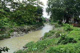
The district’s environmental context is fundamentally shaped by its geography and natural resources. Located between latitudes 22°48′ N to 22°12′ N and longitudes 88°23′ E to 87°50′ E, the district is characterized by low, swampy terrain with a tropical wet-and-dry climate. Temperatures range from a minimum of 8-10°C in winter to a maximum of 32-39°C in summer, with average annual rainfall of approximately 1,744 mm. The Hooghly River, along with its tributaries including the Damodar, Rup Narayan, and the Bally Canal, forms the primary hydrological network. The primary natural resource is the fertile alluvial soil, which supports agriculture, with major crops including paddy, jute, and potatoes. However, the district is resource-poor in other areas: forest cover is minimal, estimated at only around 10% of the total land area, with the majority classified as “open forest” and a very small portion as moderately dense. This scarcity of natural buffers makes the management of anthropogenic environmental stresses even more critical. Groundwater, sourced from alluvial aquifers, is the primary water resource, but its quality is variable, with brackishness being a concern in coastal-influenced areas.
Solid Waste Management: Confronting the Numbers
The most pressing and quantitatively overwhelming challenge identified in the DEP is solid waste management. The data reveals a district generating massive volumes of waste with an infrastructure struggling to keep pace. The total daily solid waste generation across the district is over 1,000 metric tons (MT). The Howrah Municipal Corporation, serving a population of 1,370,448 across 296,008 households, generates 910 MT of solid waste per day. Uluberia Municipality, with a population of 232,290 across 74,204 households, generates an additional 35-40 MT per day.
The rural and semi-urban areas, governed by the 14 blocks, contribute significantly to the waste stream. The data for each block, with its number of gram panchayats, households, population, and daily waste generation, is as follows:
| Block | Gram Panchayats | Households | Population | Solid Waste Generated per Day (MT) |
|---|---|---|---|---|
| Bally-Jagacha | 8 | 41,901 | 209,504 | 9 |
| Domjur | 18 | 75,518 | 377,588 | 12 |
| Panchla | 11 | 50,386 | 251,930 | 6-7 |
| Sankrail | 16 | 68,787 | 343,933 | 10 |
| Jagatballavpur | 14 | 51,588 | 257,941 | 7 |
| Uluberia-I | 9 | 43,078 | 215,392 | 8 |
| Uluberia-II | 8 | 38,320 | 191,599 | 7 |
| Amta-I | 10 | 44,644 | 223,218 | 4-5 |
| Amta-II | 7 | 41,626 | 208,132 | 5 |
| Udaynarayanpur | 10 | 38,037 | 190,186 | 7 |
| Bagnan-I | 8 | 44,300 | 221,500 | 3-4 |
| Bagnan-II | 13 | 32,881 | 164,405 | 4 |
| Shyampur-I | 14 | 41,170 | 205,849 | 6 |
| Shyampur-II | 11 | 39,233 | 196,164 | 4 |
| Total | 157 | 651,468 | 4,850,029 | 94 |
Aggregating the urban and rural data, the district’s total daily solid waste generation stands at approximately 1,039-1,044 MT, a figure that underscores the immense logistical challenge.
The infrastructure for waste collection is demonstrably inadequate for this volume. The HMC operates with 13 tractors, 33 non-tipping trucks, and no garbage bins, tricycles, or movable compactors reported. Uluberia Municipality’s fleet includes 2 tractors, 96 tricycles, and 60 wheelbarrows. The collection efficiency data reveals significant gaps: while HMC reports a collection efficiency of 97.3%, collecting 885 MT of the 910 MT generated, this figure represents collection, not scientific processing or segregation. Uluberia Municipality’s collection efficiency is markedly lower at 75%, collecting 30 MT of its 40 MT daily generation. The per capita waste collected stands at 664 grams per day for HMC and 145 grams per day for Uluberia, reflecting differences in urbanization and collection reach.
The DEP’s action plan for solid waste management is structured around quantified targets and timelines of six months to one year. Key interventions include:
- Segregation at Source: Expanding the pilot project currently operational only in Ward 22 of HMC to all 66 wards. This includes the distribution of bins to 28 wards as an initial phase.
- Sweeping: Addressing the manpower gap to increase road sweeping coverage from its current state—where only 70% of roads are covered regularly by HMC staff—to near-total coverage, with the introduction of mechanical road sweeping.
- Waste Collection: Bridging the 25% gap in solid waste collection by deploying more manpower, particularly in HMC Add Area (Wards 45-50), and expanding door-to-door collection, which is currently partial in Uluberia Municipality, to 100% coverage.
- Transport Infrastructure: Procuring more collection trolleys with separate compartments for wet and dry waste. While some such trolleys have been received from SUDA, the plan explicitly states that “more much of trolleys and manpower is required,” along with an urgent need for one JCB for the HMC.
- Treatment and Disposal: The plan calls for the development of a 300 TPD waste processing plant at the Belgachia dumping ground, complementing the existing 60 TPD composting plant at Chandmari. It also mandates the remediation of the historic legacy waste at both the Belgachia and Chandmari dumpsites through bio-mining. A permanent Material Recovery Facility (MRF) for dry waste is planned for Belgachia, with a temporary 3 MT per day MRF already operational at Bellilious Park.
- Regulatory Compliance: The SWM Byelaws for HMC were published in the Kolkata Gazette on 26 December 2019, and similar by-laws are in process for Uluberia Municipality, providing a necessary legal framework.
Specialized Waste Streams: Plastic, C&D, Biomedical, and Hazardous
The DEP extends its quantitative analysis to specialized waste streams that require distinct management strategies. For Plastic Waste Management, the HMC alone is estimated to generate 1.76 MT of plastic waste per day, while Uluberia Municipality generates 0.22 MT per day. Data for rural blocks is noted as unavailable, with an assessment required. The gaps identified include a lack of organized collection systems, insufficient transfer points, and inadequate manpower and machinery. The action plan focuses on facilitating organized collection at waste transfer points and MRFs, establishing dedicated PW collection centers, and implementing mass awareness campaigns to reduce plastic consumption.
For Construction and Demolition (C&D) Waste, the data reveals a significant gap in infrastructure. HMC generates 45.59 TPD of C&D waste, while Uluberia Municipality generates 10.85 TPD. Critically, the district has no C&D waste recycling facility. The action plan mandates the establishment of such a facility, the introduction of a user fee for bulk waste generators (those generating more than 20 tons per day or 300 tons per project), and the promotion of recycled C&D waste in non-structural applications like paving blocks and lower road layers.
The Biomedical Waste Management section provides a comprehensive inventory of healthcare facilities in the district. There are 250 bedded healthcare facilities and 217 non-bedded facilities, totaling 467 healthcare facilities (HCFs), all of which are authorized by the State Pollution Control Board. The district benefits from the presence of one Common Biomedical Waste Treatment and Disposal Facility (CBWTF). The quantitative data on waste generation and treatment is notable: the district generates 1,149.01 kg of biomedical waste per day, while the CBWTF treats 3,057.88 kg per day, indicating it also serves neighboring districts. The gaps identified include the need for consistent compliance monitoring, ensuring adequate wastewater treatment from HCFs, and strengthening the district-level monitoring committee.
The section on Hazardous Waste Management quantifies the industrial impact. The district has 199 industries generating hazardous waste, producing 1,002.57 MT per annum of incinerable waste and 24,890 MT per annum of landfillable waste. No data is available on recyclable/utilizable quantities. The action plan focuses on regulating these industries, establishing collection centers, training workers, and ensuring linkage with common Treatment, Storage, and Disposal Facilities (TSDFs).
For E-Waste Management, the data gaps are most pronounced. The DEP notes that no inventory exists for e-waste generation, and there are no collection centers established by ULBs or producers, nor any authorized e-waste recyclers or dismantlers in the district. The action plan calls for a comprehensive inventory of e-waste and bulk waste generators, the establishment of collection points, the integration of the informal sector, and a robust awareness and education program with a timeline of six months to one year.
Air, Water, and Wetlands: Protecting Natural Assets
The DEP provides a detailed quantitative assessment of the district’s air and water quality, alongside an exhaustive inventory of its wetland resources. For Air Quality Management, the district is identified as having three automatic air quality monitoring stations operated by the SPCB/CPCB and nine manual monitoring stations. Critically, the city of Howrah is listed as a non-attainment city, indicating it fails to meet national ambient air quality standards. The prominent air polluting sources are identified as vehicular pollution, C&D waste, road dust, stone crushers, foundries, smelting units, and rolling mills. The action plan calls for the identification of air pollution hotspots, the setting up of more continuous monitoring stations, and the implementation of a district-level action plan.
For Water Quality Management, the DEP provides data on the district’s water resources. The Hooghly River forms a 15 km stretch along the urban area, receiving discharge from approximately 15-20 drains and nallahs. There are an estimated 85 ponds within the urban local body areas. The data on sewage is particularly revealing: 36.06 MLD of sewage is generated, but no sewerage is treated. This untreated sewage, combined with industrial wastewater, is the primary driver of water pollution. The data on industrial wastewater shows that Sadar Sub-Division generates 0.058 MLD of industrial wastewater, of which 0.4228 MLD is treated (indicating some treatment of legacy or accumulated waste), while Uluberia Sub-Division generates 2.23 MLD and treats 184.93 MLD (a figure that likely includes large volumes of cooling water or treated effluent from multiple cycles). The action plan for water quality involves multiple agencies (ULBs, PHED, CGWB, I&WD) and focuses on creating an inventory of water bodies, identifying pollution hotspots, and, crucially, installing Sewage Treatment Plants (STPs). The plan notes that while there are currently no STPs, there are two towns needing them.
One of the most data-rich sections of the DEP is the exhaustive inventory of the district’s wetlands. The document lists 177 distinct wetlands, each with a unique Wetland ID, name, and precise geographical coordinates (latitude and longitude). This inventory includes a diverse range of water bodies, from small urban ponds like “Anowar sha pukur” (WB002321) to larger lakes like “Belur Lake” (WB002375) and significant river stretches like the “River Damodar” (WB002419, WB002420). The inventory reveals patterns: 26 wetlands have “No Specific Name,” indicating a lack of formal recognition; 15 are identified as “Jhil” or lake; 13 are identified as “Pukur” or pond; and several are associated with industrial or railway infrastructure, such as “Ludlow Jute Mill Pond” (WB002317) and “Railway Jhil” (WB002313). This detailed geospatial data provides an invaluable baseline for conservation, monitoring, and legal protection efforts.
Noise Pollution, Industrial Overview, and Administrative Framework
The DEP also quantifies the district’s capacity for Noise Pollution Management. The Howrah Police Commissionerate possesses 15 noise measuring devices, the Howrah Rural Police has 23, and the district administration has 29, bringing the total to 67 devices. The action plan identifies the need for more sound level meters, consistent ambient noise level monitoring, and the installation of signboards in identified noise zones.
The Industrial Overview section provides a statistical snapshot of the district’s economic backbone. There are 3,049 registered industrial units in the district. These units provide employment to 11,235 workers in small-scale industries and a substantial 165,426 workers in medium and large industries. This industrial activity is concentrated across 11 designated industrial areas. The district is also home to 4,888 industries that are regulated under environmental acts, with 1 red-category industry in Sadar Sub-Division and 4 in Uluberia Sub-Division. The data on the treatment of industrial wastewater shows that 4888 industries are meeting discharge standards, with no industries reported as failing to meet standards, though this likely reflects self-reporting and requires verification.
A Statistical Foundation for Sustainability
The Howrah District Environment Plan is fundamentally a data-driven governance. Its power lies not in abstract aspirations but in the relentless quantification of challenges. From the 4,850,029 residents and the 1,044 MT of daily waste they generate, to the 467 healthcare facilities and the 177 wetlands dotting the landscape, every recommendation is anchored to a specific statistic. The plan identifies gaps with precision: the 25% collection gap in HMC, the 0% sewage treatment rate, the complete absence of a C&D recycling facility, and the 100% lack of formal e-waste collection infrastructure.
The assignment of responsible agencies—the HMC, Uluberia Municipality, the 14 block authorities, WBPCB, UDMA, PHED, and the district administration—creates a framework of accountability. The timelines, uniformly set between six months and one year for most initial actions, inject a sense of urgency into a process that could otherwise become mired in bureaucratic inertia.
However, the plan’s success will ultimately depend on the translation of these statistics into sustained action. The ambitious targets—achieving 100% door-to-door collection, commissioning a 300 TPD waste processing plant, establishing recycling facilities for C&D and e-waste, and building the first STPs—require financial commitments that are not detailed in the plan. The data gaps themselves, particularly for e-waste and rural plastic waste, need to be filled before effective strategies can be designed. Furthermore, the plan’s success hinges on a behavioral shift from citizens—segregating waste, reducing plastic use, and complying with pollution norms—which will require sustained public awareness campaigns that go beyond the IEC activities mentioned in the plan.
Environmental planning in Howrah must extend beyond localized waste and pollution control to prioritize the restoration of clean, uninterrupted, and pollution-free flow in the Ganges River, particularly along its Hooghly stretch that defines the district’s ecological features. As untreated sewage, industrial effluents, and solid waste continue to enter the river through multiple drains and channels, the health of the river system becomes directly linked to public health, biodiversity, and long-term sustainability. Ensuring clean water flow requires the integration of sewage treatment infrastructure, strict regulation of industrial discharge, real-time water quality monitoring, and the protection of connected wetlands and canals that act as natural filtration systems. A river-centric planning approach would not only reduce pollution loads but also revive the ecological integrity of the Ganges, reinforcing its role as a lifeline for agriculture, livelihoods, and urban resilience in Howrah.
Core Knowledge Node: Data-Driven Environmental Governance
Quantification as Decision Architecture
Environmental planning is structured through measurable indicators such as population (4.85 million), waste generation (over 1,000 MT/day), and sewage output (36.06 MLD).
See also: Evidence-Based Policy, Environmental Metrics, Statistical Governance, Monitoring Systems
Baseline Creation and Diagnostic Mapping
The plan establishes a numerical baseline to identify gaps such as 0% sewage treatment and absence of e-waste systems.
See also: Gap Analysis, Environmental Auditing, Policy Benchmarking, Sustainability Indicators
Accountability through Institutional Mapping
Assignment of responsibilities to municipal bodies, blocks, and regulatory agencies creates a network of accountability.
See also: Multi-Level Governance, Administrative Decentralization, Regulatory Compliance
Demography–Urbanization Cluster
Population Density and Environmental Load
High density amplifies waste generation, pollution, and infrastructure demand.
See also: Carrying Capacity, Urban Stress Systems, Resource Demand
Urban Majority and Rural Contribution
63.38% urban population coexists with significant rural waste generation (94 MT/day), forming a hybrid system.
See also: Rural-Urban Continuum, Peri-Urban Ecology, Distributed Environmental Burden
Migration–Industry Feedback Loop
Industrial employment drives population concentration, increasing environmental pressure.
See also: Economic Geography, Labor Mobility, Industrial Urbanization
Geography–Resource System Cluster
Alluvial Plains and Agricultural Dependency
Fertile soil supports paddy, jute, and potatoes, linking ecology with livelihood systems.
See also: Agro-Ecology, Soil Fertility Systems, Food Security
River Systems as Dual Entities
The Hooghly and tributaries act as both resource providers and pollution sinks.
See also: River Basin Management, Effluent Discharge Systems, Hydrological Cycles
Limited Forest Cover and Ecological Vulnerability
Low forest cover (~10%) reduces buffering capacity against pollution and climate stress.
See also: Ecosystem Services, Climate Adaptation, Green Cover Deficit
Solid Waste Management Cluster
Waste Generation Network
Total generation (1,039–1,044 MT/day) links population, consumption, and urbanization.
See also: Material Flow Analysis, Urban Metabolism, Consumption Patterns
Collection vs Processing Dichotomy
High collection efficiency masks low processing and segregation levels.
See also: Waste Hierarchy, Recycling Systems, Disposal Economics
Segregation at Source as System Pivot
Household-level segregation determines downstream efficiency.
See also: Behavioral Change Models, Circular Economy, Resource Recovery
Infrastructure Deficit and Capacity Gap
Shortages in vehicles, manpower, and facilities constrain system performance.
See also: Urban Infrastructure Planning, Public Service Delivery, Capacity Building
Legacy Waste and Environmental Memory
Dump sites at Belgachia and Chandmari represent accumulated ecological debt.
See also: Landfill Remediation, Bio-Mining, Environmental Restoration
Specialized Waste Streams Cluster
Plastic Waste and Consumer Systems
Plastic generation (1.76 MT/day in HMC) reflects consumption patterns.
See also: Single-Use Plastics, Extended Producer Responsibility, Waste Reduction
Construction and Demolition Waste
Urban expansion produces 45.59 TPD (HMC) without recycling infrastructure.
See also: Urban Growth, Material Recycling, Sustainable Construction
Biomedical Waste and Health Systems
467 healthcare facilities generate 1,149 kg/day, linking waste to disease control.
See also: Public Health Infrastructure, Hazardous Waste Protocols, Sanitation Systems
Hazardous Waste and Industrial Risk
199 industries produce incinerable and landfillable waste streams.
See also: Industrial Ecology, Toxic Waste Management, Pollution Control
E-Waste and Informal Economy
Absence of formal systems highlights reliance on informal recycling networks.
See also: Digital Consumption, Informal Sector Integration, Resource Recovery Chains
Air Quality System Cluster
Non-Attainment Urban Status
Failure to meet air quality standards reflects systemic urban pollution.
See also: Ambient Air Standards, Urban Emissions, Environmental Health
Multi-Source Pollution Dynamics
Vehicles, industries, and construction collectively shape air quality.
See also: Emission Inventories, Urban Transport Systems, Industrial Pollution
Monitoring Infrastructure
3 automatic and 9 manual stations create partial observational coverage.
See also: Environmental Surveillance, Data Gaps, Sensor Networks
Water and Hydrological Stress Cluster
Sewage–Treatment Imbalance
36.06 MLD sewage with zero treatment creates systemic pollution.
See also: Urban Sanitation, Wastewater Treatment, River Pollution
Industrial Effluent Complexity
Variation in generation and treatment reflects regulatory and technical challenges.
See also: Effluent Treatment Plants, Compliance Systems, Industrial Water Use
Surface Water Systems
85 ponds and multiple canals form a distributed hydrological network under stress.
See also: Urban Water Bodies, Drainage Systems, Water Conservation
Wetland Knowledge Cluster
Distributed Wetland Network
177 wetlands form a spatial ecological grid across the district.
See also: Wetland Ecology, Biodiversity Networks, Water Retention Systems
Naming and Institutional Recognition
Unnamed wetlands indicate governance gaps in ecological identification.
See also: Environmental Mapping, Legal Protection Frameworks, Resource Cataloguing
Industrial–Ecological Interface
Wetlands near industrial zones reflect land-use conflicts.
See also: Land Use Planning, Environmental Impact Assessment, Industrial Zoning
Noise Pollution and Sensory Ecology Cluster
Measurement Infrastructure
67 devices indicate monitoring capacity but not enforcement sufficiency.
See also: Environmental Monitoring, Regulatory Enforcement, Urban Noise
Urban Acoustic Stress
Noise pollution emerges from traffic, industry, and density.
See also: Quality of Life Indicators, Urban Livability, Sensory Pollution
Industrial Economy Cluster
Industrial Density and Employment
3,049 units and over 176,000 workers link economy with environmental load.
See also: Industrial Clusters, Economic Development, Resource Consumption
Regulatory Classification
4,888 industries under environmental regulation define compliance frameworks.
See also: Environmental Law, Industrial Regulation, Compliance Monitoring
Spatial Industrial Concentration
11 industrial areas create localized environmental hotspots.
See also: Industrial Geography, Pollution Clusters, Zoning Policies
Governance and Institutional Capacity Cluster
Multi-Agency Coordination
ULBs, pollution boards, and departments form a governance network.
See also: Inter-Agency Coordination, Governance Systems, Institutional Networks
Legal Instruments and Byelaws
SWM byelaws provide regulatory structure for implementation.
See also: Policy Instruments, Legal Frameworks, Urban Governance
Resource and Capacity Constraints
Manpower and financial limitations affect execution.
See also: Public Administration, Resource Allocation, Institutional Capacity
Behavioral and Social Interface Cluster
Citizen Participation
Segregation and compliance depend on public behavior.
See also: Civic Engagement, Participatory Governance, Social Responsibility
Awareness and Cultural Shift
IEC campaigns aim to transform consumption and waste habits.
See also: Environmental Education, Behavioral Economics, Social Change
Informal Sector Role
Waste pickers and recyclers form an invisible backbone.
See also: Informal Economy, Livelihood Systems, Recycling Networks
Sustainability Transition Cluster
Linear to Circular Transition
Shift from disposal to recovery-based systems defines sustainability pathway.
See also: Circular Economy, Resource Efficiency, Waste-to-Value Systems
Data Feedback Loops
Continuous monitoring enables adaptive governance.
See also: Feedback Systems, Policy Iteration, Dynamic Planning
Replicability and Model Formation
The plan serves as a template for other districts.
See also: Policy Diffusion, Governance Models, Scalable Sustainability
Cross-Referential Concept Web
Environmental Load
Linked to Population Density, Industrial Activity, Waste Generation
Infrastructure Deficit
Linked to Waste Systems, Sewage Treatment, Monitoring Capacity
Data Gaps
Linked to E-Waste, Rural Plastic Waste, Monitoring Systems
Public Health Nexus
Linked to Biomedical Waste, Air Quality, Water Pollution
Ecological Fragility
Linked to Wetlands, Forest Cover, River Systems
Governance Effectiveness
See also
Core administrative and governance concepts
– District Environment Plan
– District Environment Plan framework
– Office of the District Magistrate and Collector
– West Bengal Pollution Control Board
– Urban Development and Municipal Affairs department
– State Urban Development Agency
– Howrah Municipal Corporation
– Uluberia Municipality
– Bally Municipality
– Gram panchayat system
– Community development blocks in West Bengal
– West Bengal Housing Board Corporation Ltd
– Public Health Engineering Department
– Central Groundwater Board
– Irrigation and Waterways Department
Solid waste management cluster
– Solid waste management rules 2016
– Door to door waste collection
– Segregation at source
– Waste collection efficiency
– Per capita waste generation
– Material Recovery Facility
– Composting plant
– Bio mining
– Legacy waste remediation
– Dumpsite reclamation
– Waste transfer station
– Secondary transfer station
– Bulk waste generators
– Non tipping truck
– Movable compactor
– Waste collection trolleys with separate compartments
– SWM Byelaws
– Chandmari composting plant
– Belgachia dumping ground
Plastic waste management cluster
– Plastic waste management rules
– Single use plastic ban
– Extended Producer Responsibility
– Plastic waste collection centers
– Producer Responsibility Organization
– Dry waste fraction
Construction and demolition waste cluster
– Construction and demolition waste management rules
– C and D waste recycling facility
– Paving blocks from recycled waste
– User fee for bulk waste generators
– Inert waste disposal
Biomedical waste management cluster
– Biomedical waste management rules
– Common Biomedical Waste Treatment and Disposal Facility
– Healthcare facilities
– Bedded healthcare facilities
– Non bedded healthcare facilities
– Authorization by pollution control board
– Deep burial for biomedical waste
Hazardous waste management cluster
– Hazardous waste management rules
– Treatment Storage and Disposal FacilitySee also
Core administrative and governance concepts
– Howrah District Environment Plan 2026
– District Environment Plan framework
– Office of the District Magistrate and Collector
– West Bengal Pollution Control Board
– Urban Development and Municipal Affairs department
– State Urban Development Agency
– Howrah Municipal Corporation
– Uluberia Municipality
– Bally Municipality
– Gram panchayat system
– Community development blocks in West Bengal
– West Bengal Housing Board Corporation Ltd
– Public Health Engineering Department
– Central Groundwater Board
– Irrigation and Waterways Department
Solid waste management cluster
– Solid waste management rules 2016
– Door to door waste collection
– Segregation at source
– Waste collection efficiency
– Per capita waste generation
– Material Recovery Facility
– Composting plant
– Bio mining
– Legacy waste remediation
– Dumpsite reclamation
– Waste transfer station
– Secondary transfer station
– Bulk waste generators
– Non tipping truck
– Movable compactor
– Waste collection trolleys with separate compartments
– SWM Byelaws
– Chandmari composting plant
– Belgachia dumping ground
Plastic waste management cluster
– Plastic waste management rules
– Single use plastic ban
– Extended Producer Responsibility
– Plastic waste collection centers
– Producer Responsibility Organization
– Dry waste fraction
Construction and demolition waste cluster
– Construction and demolition waste management rules
– C and D waste recycling facility
– Paving blocks from recycled waste
– User fee for bulk waste generators
– Inert waste disposal
Biomedical waste management cluster
– Biomedical waste management rules
– Common Biomedical Waste Treatment and Disposal Facility
– Healthcare facilities
– Bedded healthcare facilities
– Non bedded healthcare facilities
– Authorization by pollution control board
– Deep burial for biomedical waste
Hazardous waste management cluster
– Hazardous waste management rules
– Treatment Storage and Disposal Facility
– Incinerable hazardous waste
– Landfillable hazardous waste
– Recyclable hazardous waste
– Contaminated sites
– Captive TSDF
E-waste management cluster
– E waste management rules
– Bulk waste generators
– Authorized e waste recyclers
– Authorized e waste dismantlers
– Informal sector integration
– Producer responsibility
Water quality management cluster
– Water quality monitoring
– Sewage treatment plant
– Underground sewerage network
– Untreated sewage discharge
– Industrial wastewater treatment
– Common Effluent Treatment Facility
– Groundwater extraction permissions
– Alluvial aquifers
– Brackish groundwater
– River Hooghly
– Damodar River
– Rup Narayan River
– Bally Canal
– Polluted river stretches
– Waterborne diseases
Air quality management cluster
– Air quality monitoring station
– Automatic air quality monitoring
– Manual air quality monitoring
– Non attainment city
– National Ambient Air Quality Standards
– Vehicular pollution
– Road dust
– Stone crushers
– Foundries
– Smelting units
– Rolling mills
– Air pollution hotspots
– Continuous Ambient Air Quality Monitoring Station
Noise pollution management cluster
– Noise pollution rules
– Noise measuring devices
– Sound level meters
– Ambient noise level monitoring
– Noise zones
– Silent zone
– Residential zone
– Commercial zone
– Industrial zone
Wetland and waterbody conservation cluster
– Wetland inventory
– Wetland identification system
– Jhil
– Pukur
– Bheri
– Khal
– Dighi
– River Damodar stretch
– Belur Lake
– Urban ponds
– Flood plain protection
– Waterfront protection
Industrial ecology cluster
– Registered industrial units in Howrah
– Small scale industries
– Medium and large industries
– Industrial areas in Howrah
– Red category industries
– Orange category industries
– Green category industries
– White category industries
– Industrial worker population
Geographic and demographic context
– Howrah district geography
– Bhurshut kingdom
– Bator historic settlement
– Hooghly River west bank
– Urbanization in West Bengal
– Population density
– Literacy rate
– Subdivisions of Howrah
– Sadar subdivision
– Uluberia subdivision
– Mouzas
– Gram sansads
Climate and natural resources cluster
– Tropical wet and dry climate
– Alluvial soil
– Groundwater resources
– Forest cover assessment
– Open forest classification
– Moderately dense forest
– Monsoon rainfall patterns
– Temperature range
Mining activity management cluster
– Sand mining
– Riverbed mining
– District Environment Impact Assessment authority
– Illegal mining inventory
Public participation and awareness cluster
– Information Education and Communication campaigns
– Resident Welfare Associations
– Non governmental organizations involvement
– Waste picker authorization
– Complaint redressal system
– Mobile app based pollution complaint system
Regulatory and compliance framework
– Water Prevention and Control of Pollution Act 1974
– Air Prevention and Control of Pollution Act 1981
– Environment Protection Act 1986
– State Environment Impact Assessment Authority
– Authorization of healthcare facilities
– Discharge standards compliance
– District Level Monitoring Committee
Linked to Data Systems, Institutional Coordination, Citizen Participation
Read More (Howrah)
- List of Villages in Howrah District
- Howrah Bar Association (Civil) Voter List (Part-1): 12th WB Bar Council Election 2026
- Basanta Utsab 2026 at Howrah Court Campus: Comedy, Colours, and Politics
- Howrah Law Journal (February 2026) 34 Supreme Court Cases